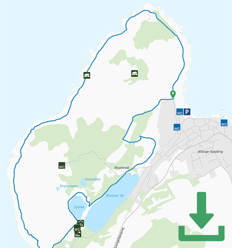
Article

Hiking trail: Round the Hammerknuden Rock

The classic hike in the best of Bornholm’s scenery: A hike round the iconic Hammerknuden rock in the far north.

Gitte Holtze

Hiker and outdoor freak as well as journalist, lecturer and author of "jeg lever" about Gitte's hike along the Pacific Crest Trail and "Gå langt", a guidebook to long hikes.

Trekandtell.dk

Facts

Duration:
Two hours
Length:
7 km (round trip)
Difficulty level:
Relatively difficult. The terrain is hilly and rocky
Suitable for prams and wheelchairs:
No
Parking:
In the car park by Sandvig beach. The address is Sandlinien
Toilets:
In the car park
Access to water:
The public toilets at the car parks
Surface:
Asphalt, nature path, rocks and gravel path
Special remarks:
The route doesn’t go via Hammerhavn (Hammer Harbour), but a pitstop in this cosy little harbour is well worth the just 200-metre detour (each way).


Map of the route

Below you can download a pdf with an A4 map of the route.

Route description

For most people, no trip to Bornholm is complete without a walk around the distinctive promontory to the north: Hammeren (the Hammer) or Hammerknuden. The most popular route follows the coast most of the way and starts at the end of the car park at Sandvig beach.

The hike is a round trip, so in principle you can start anywhere. However, it makes sense for most people to park at Sandvig beach, where there is a large car park. Follow the blue dots from the car park along the coast along a wide paved path to the first part towards Hammerodde Fyr (Hammer Odde Lighthouse). The lighthouse was built in 1895 as a supporting lighthouse to Hammerfyret, which is located on the Hammeren itself, but which could not be seen in dense fog.

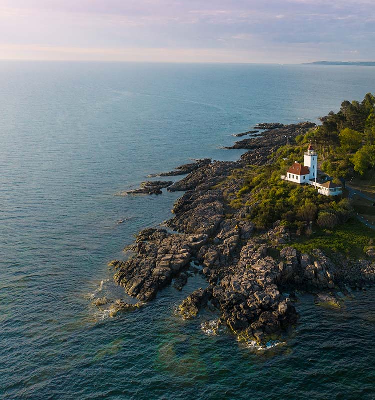
Hammerodde Lighthouse


At the lighthouse, turn off the paved road onto a narrow, hilly, rocky path close to the water, and the next three kilometres around Hammeren are walked here. Occasionally the path widens and is made of gravel, and it also has some flat stretches. However, be prepared for some ups and downs on uneven rocky surfaces; in some places you may need a helping hand.

Along the way you pass the over 700-year-old ruins of Solomon’s Chapel and you’ll go far up over the sea to an amazing view down over Hammerhavn (Hammer Harbour).

Just before you reach the descent to Hammerhavn, the route turns sharp left away from the coast (and the Kyststien, which is also here but goes down to the harbour) and steeply uphill towards the rocky knoll above Opalsøen (the Opal Lake).

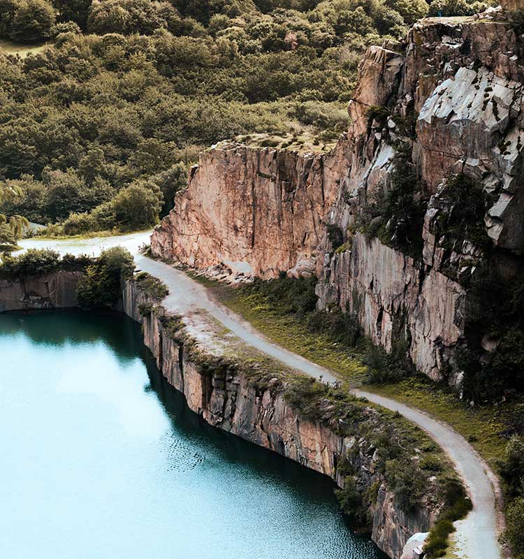
The Opal Lake seen from above

Keep a close eye on the signposts, because for the next kilometre the route winds several times through the tree-covered terrain high above Opalsøen. Before it goes down again on the other side of the lake, you reach the shore of Hammersø, which you follow back to Sandvig.


Places on the route:

On this hike, you get a chance to visit the following places:

1

Dideriks Veranda

Dideriks Veranda is a cosy café and arts and crafts shop. It serves a delicious buffet, freshly squeezed juice, coffee and cake. You can also browse the shop, which sells beautiful handicrafts and Bornholm delicacies. See opening hours here

2

Sandvig Is Kalas

Sandvig IS Kalas and the café Kalas-Kalas are located in the middle of the cliffs at Sandvig Harbour. Here, ice cream is produced daily from organic milk from Bornholm and with fruit from the island’s gardens. Enjoy the freshly roasted coffee while dipping your toes in the water, or from the terrace overlooking Hammerknuden. See opening hours here

3

Spisestedet Kokkenberg (The Kokkenberg Eatery)

Kokkenberg is a lovely eatery located in the cosy harbour town of Sandvig. The restaurant serves good, honest food in beautiful surroundings. See opening hours here

4

Ellas Restaurant & Konditori in Sandvig

Ellas Restaurant & Konditori is located in an interesting old half-timbered house close to Sandvig beach. Visit this unique eatery with its cosy garden and beautiful old rooms. See opening hours here

5

Salomon’s Chapel (Salomons Kapel)

You will reach Salomon’s Chapel on the hike along the Hammerknuden coastline. Salomon’s Chapel is a small chapel that was built in the 13th century for the many herring fishermen who came to have their catch blessed

6

Sandvig Beach

Sandvig beach is at the foot of Hammerknuden on the northern tip of Bornholm. Wheelchair-accessible paths have been built from the car park to and along the entire beach.

Find more hiking paths here

Bornholm is a paradise for any nature lover. Find more hiking paths below...

Theme
Bornholm's Hiking Guide - Get tips for the best hiking trails here
Theme
Read all about hiking on Bornholm here
0
You have no favorites
You have 1 favourite
You have 0 favourites
Send us an e-mail
Write to us.

Send us an e-mail:

info@bornholm.info

Tourist information
Call us
Call us

On the phone:

(+45) 56 95 95 00