Article

Hiking route: Almindingen Forest, The Bison Trail

In 2012, a herd of bison was released in Almindingen Forest. On this route, you will enter their territory and have the chance to see the mighty animals closer up.

Gitte Holtze

Hiker and outdoor freak as well as journalist, lecturer and author of "jeg lever" about Gitte's hike along the Pacific Crest Trail and "Gå langt", a guidebook to long hikes.

Trekandtell.dk

Facts

Duration:
3 hours
Length:
Approximately 12 km (round trip)
Difficulty level:
Medium A few hilly stretches and marshy in wet weather
Suitable for prams and wheelchairs:
No
Parking:
At the car park at Hareløkkerne, at Bastemose (Baste Bog) or at the entrance to Bisonskoven on Christian X’s Vej
Toilets:
In the car park at Hareløkkerne
Access to water:
At the toilets in the car park at Hareløkkerne and near the entrance to the Bisonskoven on Christian X’s Vej.
Surface:
Primarily wide forest paths, as well as nature trail
Special remarks:
Walk slowly and keep your distance from the bison if you see them, preferably 80-100 metres.


Map of the route

Below you can download a pdf with an A4 map of the route.
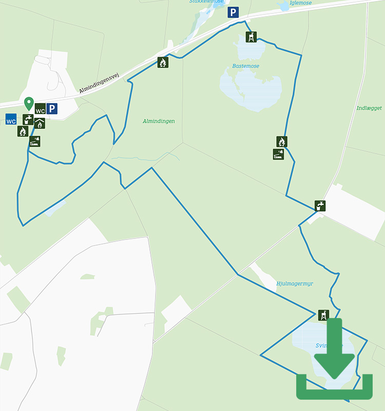
Route description

If you set off from Hareløkkerne, follow the purple markers for a few hundred metres and then they split into two directions – this is because the first stretch of the route is also the last; you therefore have to choose from here whether to walk clockwise or anti-clockwise (you end up back here anyway).

Walking clockwise, you have to turn sharp left and climb steeply through the forest. The route takes a few sharp turns, but is well signposted, and soon you’re on a gravel path along the Segensvej road. From here it’s back into the forest and along a pretty bridge over the bird paradise Bastemose and past the pleasant Lindesbjerg shelter.

A few hundred metres later you reach the solid gate into Bisonskoven itself.

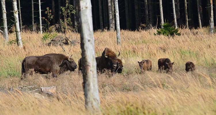
The Bison in Almindingen


The fenced area is about 200 hectares in size, and there are currently 10 bison living in it. Where they are exactly in the forest, only they know, so there’s no guarantee of seeing them on your walk here. But you never know so follow the route around the bison’s ‘home’ – it’s a couple of kilometres long, alternating between small paths and wider roads in a loop around the densely forested and beautiful area.

Out of the forest again the route goes back towards Hareløkkerne mainly on wide forest roads. Keep an eye on the markings, as there are a few sharp turns along the way.


Places on the route:

On this hike, you get a chance to visit the following places:

1

Ekkodalen

Explore Ekkodalen on Bornholm. The beautiful Ekkodal is Bornholm’s largest rift valley.

2

Rytterknægten

Pass by Rytterknægten in Almindingen Forest on Bornholm – it’s the highest point on the island!

Find more hiking paths here

Bornholm is a paradise for any nature lover. Find more hiking paths below...

Theme
Bornholm's Hiking Guide - Get tips for the best hiking trails here
Theme
Read all about hiking on Bornholm here
0
You have no favorites
You have 1 favourite
You have 0 favourites
Send us an e-mail
Write to us.

Send us an e-mail:

info@bornholm.info

Tourist information
Call us
Call us

On the phone:

(+45) 56 95 95 00