Article

Hiking route: Kobbeådalen Valley

Lush vegetation is what you’ll see all around you in this rift valley with its high, steep cliff sides and the Stavehøl Waterfall, an impressive experience in itself.

Gitte Holtze

Hiker and outdoor freak as well as journalist, lecturer and author of "jeg lever" about Gitte's hike along the Pacific Crest Trail and "Gå langt", a guidebook to long hikes.

Trekandtell.dk

Facts

Duration:
An hour and a half
Length:
Approximately 2 km (each way)
Difficulty level:
Medium. Not hilly, but a narrow nature path, which gets muddy in wet weather
Suitable for prams and wheelchairs:
No
Parking:
At the car park on Melstedvej, where Kobbeå river flows into the sea (near Sannes Familiecamping) or on Kobbevej 5 – follow the signs to Stavehøl waterfall
Toilets:
In the car park
Access to water:
The public toilets at the car parks
Surface:
Forest path
Special remarks:
Come in spring, when the forest bed is covered with anemones and ramsons.


Map of the route

Below you can download a pdf with an A4 map of the route.

Route description

Cross Melstedvej a few hundred metres south of the car park and enter the forest along the forest road next to Kobbeå. This is where the river has its outlet, and although there is nothing to see here now, remains have been found here of some of Bornholm’s oldest settlements from the hunter stone age.

Kobbeådalen valley is one of Bornholm’s many rift valleys. The river runs through the bottom of the valley, with the banks on both sides sloping steeply upwards. The southern side is particularly impressive, with tall pine trees. Many of them have fallen and criss-cross the winding river. The middle of the river is full of beautiful moss-covered rocks.

From the wide forest road, turn onto a narrow path that follows the river as it winds through the valley. You’ll be walking on the north side of the river, so you won’t have to brave the fallen trees, but can simply walk along the path and enjoy the sight of nature that has been allowed to grow wild.

At the end of the winding path you will come across the Stavehøl waterfall. It has a drop of just under six metres and falls over a two-metre wide rock crevice. It is not the highest on the island, but it is nevertheless impressive with its noisy drop, especially in spring when the river is full of water.
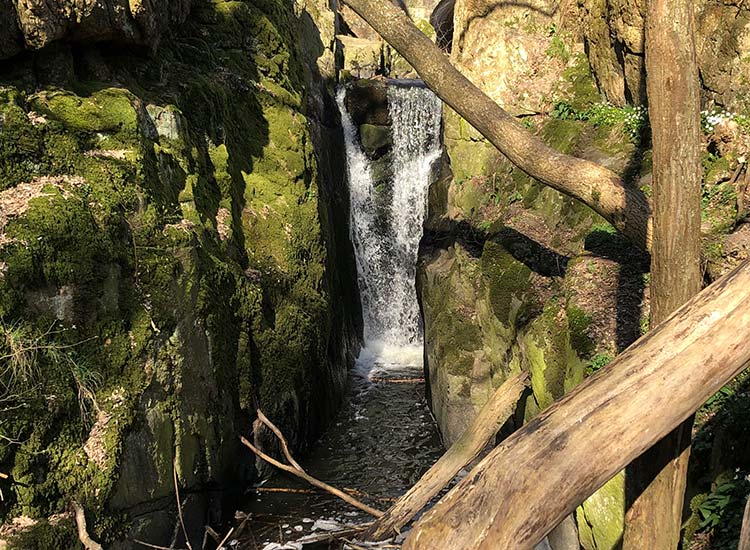
Stavehøl Waterfall

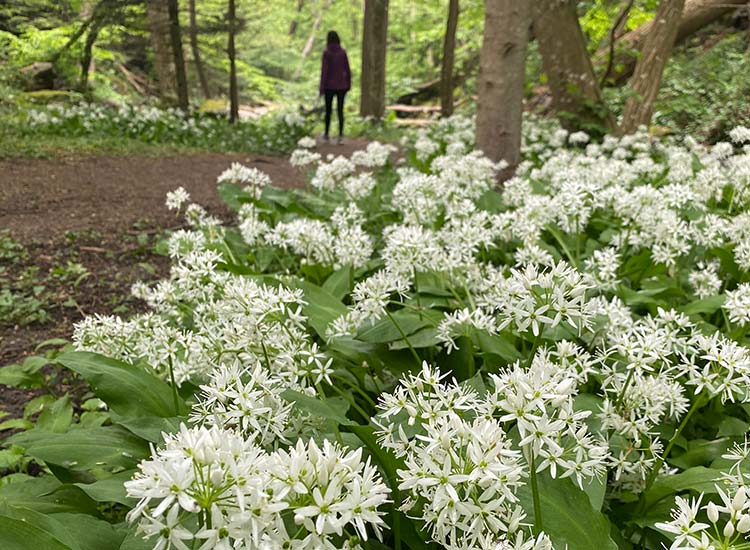
Spring is also the season when the Kobbeådalen valley is at its most beautiful, for this is when the forest bed is literally covered with ramsons and anemones, first blue, then white and yellow. A magnificent sight.

The route is not signposted, but that’s not necessary – it’s obvious where you have to go.


Places on the route:

On this hike, you get a chance to visit the following places:

1

Stavehøl vandfald

When you are on Bornholm – you should visit the waterfall Stavehøl. The waterfall has the highest vertical fall in Denmark with a free vertical fall of 3-4 metres. The waterfall is one of the most beautiful ones on the island.

2

Bornholms Adventure Minigolf

Bornholm has an 18-hole minigolf course of high character in beautiful nature. The minigolf course, situated on Sannes Familiecamping in Melsted close to Gudhjem, is not just for camping guests but is open for everyone.

Find more hiking paths here

Bornholm is a paradise for any nature lover. Find more hiking paths below...

Theme
Bornholm's Hiking Guide - Get tips for the best hiking trails here
Theme
Read all about hiking on Bornholm here
0
You have no favorites
You have 1 favourite
You have 0 favourites
Send us an e-mail
Write to us.

Send us an e-mail:

info@bornholm.info

Tourist information
Call us
Call us

On the phone:

(+45) 56 95 95 00